

13 Ancient Things that don’t make sense in History
1. Ten thousand year old boats found on Britain’s hillsides – 7,000 years before they were invented.
A small body of determined spirits fired by an unquenchable faith in their mission can alter the course of history. – Mahatma Gandhi
Synopsis
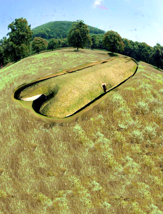
Careful examination reveals that these monuments are shaped like a boat with an open back end for a chamber which is similar to the helm of prehistoric and even boats of today where the crew would normally sleep.
If these monuments called ‘Long Barrows’ were located anywhere else such as Egypt, Greece or Asia Minor, then archaeologists would happily identify them as a representation of a sailing ship – but these ‘ships’ were built thousands of years before the current experts believe British boats were constructed.Recently, archaeologists in Asia Minor have realised that the world suffered massive flooding after the last Ice Age, so much so that areas like the Caspian and Black Seas doubled their volumes due to this ‘post-glacial flooding’ and this effect must have had similar results in Britain, which was considerably closer to the ice sheet. British Geology Maps show in the recent superficial soils that there was once major flooding that affected 90% of the mainland rising groundwater levels and swelling rivers.
This discovery has opened the distinct possibility that the ‘megalithic builders’ of Northern Europe were a single maritime civilisation that used boats to transport stone to build such monuments as Stonehenge, Avebury, Carnac and even Gobekli Tepe as the post-glacial flooding after the ice age affected not only Europe but even as far away as Asia Minor thus allowing people to travel throughout these extended continents via inland waterways.Archaeological findings in Britain also suggest that an archaic maritime civilisation did, in fact, exist in Northern Europe directly after the ice age.
As we have found prehistoric pictures on the walls of Stone in ‘the ancient trial’ of Ostflod in Norway showing double hull reed boats, wooden ‘mortice and tenon’ joints dated at 6250BC under the sea at Boulder Cliff in the Isle of Wight and most recently the discovery of the oldest boatyard in the world in South Wales, which launched not just boats but ‘catamarans’ possibly dating back to the end of the Ice Age some 10,000 years ago.The fact that these catamarans have now been found in Britain replicating the drawings in Norway clearly shows that an ancient maritime civilisation with advanced boat technology must have existed once upon a time.
2. Gigantic Canals – that are technically superior to even Victorian engineering.

A scientific truth does not triumph by convincing its opponents and making them see the light, but rather because its opponents eventually die and a new generation grows up that is familiar with it. – Max Planck
Synopsis
A ‘Dyke’ is a word used to represent either a wall or protective mound to keep out or channel water, so why do we have such large dykes such as ‘Offa’s Dyke’ on the England/Wales border and ‘Wansdyke’ in Wiltshire on top of hill’s miles away from any form of water?
It has always been believed that some of these dykes (canals) were originally built as Medieval defensive walls, but that is far from the truth. The current dating for these monuments have been obtained by artifacts found at the bottom of their ditches, and although there are mainly artefacts of Roman origin, some stone and flint tools have also been located in or near the structures, yet archaeologists are loaved to date them as prehistoric, although we have seen similar ditches contained within monuments such as Avebury, which were undertaken thousands of years before the Romans.
This type of historical confusion can be found at two of our biggest dykes in Britain. Offa’s Dyke which is over 81 miles long and named after King Offa (730 – 796) who was supposed to have built it to defend Britain against the Welsh tribes. Sadly, for traditional archaeologists, recent investigations have shown that it was used much earlier as Roman artefacts were found at the base of one of the ditches. The other is Wansdyke in Wiltshire; this dyke is over 21 miles long; it can be in places up to 65 feet wide and 8 feet deep, but it is built in a straight line with a bank to one side, which is also believed to be a defensive structure – even though attackers could walk around the edge of the ditch without obstruction.
Newly discovered ‘Post Glacial Flooding’ shown on the British Geological Maps and investigated in recent books had indicated that these dykes were constructed in a time when superficial deposits were formed by the flooding after the last ice age when man had returned to Britain less than 10,000 years ago. The Kennet and Avon Canal is a waterway in southern England with an overall length of 87 miles (140 km), made up of two lengths of navigable river linked by a canal. The name is commonly used to refer to the entire length of the navigation rather than solely to the central canal section. From Bristol to Bath, the waterway follows the natural course of the River Avon before the canal links it to the River Kennet at Newbury, and from there to Reading on the River Thames. Quite remarkably Wansdyke was constructed just 3 km north of the Kennet and Avon canal and the new prehistoric waterway maps of Britain show it had the same result of joining the River Thames to the Bristol Channel some 6-8K years before the Victorian’s great canal system.
The major difference between to two canal systems was the technique used to maintain the water levels within the canal. The Victorian used a lock system entrapping river flow; the ancients used a much more sophisticated natural system of ground water levels, which allowed the canal to be shorter and more direct. Clearly, the builders of this quite remarkable system had knowledge of hydrology far greater engineers even today. So who were these great engineers and what happened to them – patently history needs to revisit past accepted beliefs in search of true answers?The Kennet and Avon Canal is a waterway in southern England with an overall length of 87 miles (140 km), made up of two lengths of navigable river linked by a canal. The name is commonly used to refer to the entire length of the navigation rather than solely to the central canal section. From Bristol to Bath, the waterway follows the natural course of the River Avon before the canal links it to the River Kennet at Newbury, and from there to Reading on the River Thames. This project using the most effective system for its day took over 100 years to complete.Quite remarkably Wansdyke was constructed just 3 km north of the Kennet and Avon canal and had the same result of joining the River Thames to the Bristol Channel BUT some 6-8K years before the Victorian’s great canal system.
The major difference between to two canal systems was the technique used to maintain the water levels within the canal and the size of the structure. The Victorian used a lock system entrapping river flow; the ancients used a much more sophisticated natural system of ground water levels, which allowed the canal to be shorter and more direct. But more importantly, the Kennet and Avon is 6m wide and 2m deep, while the prehistoric canal was twice as wide and deep – so were the boats twice as big?
3. Roman ports miles away from the coast – when sea levels are apparently rising.
The difference between science and the fuzzy subjects is that science requires reasoning, while those other subjects merely require scholarship – Robert A Heinlein
Synopsis
When we look at old maps of Roman settlements and ports around Britain and the Mediterranean, we see that a majority are built on the coastline or waterways of these countries. This fact is not surprising as these locations would need a constant supply of goods for trading and construction. However, if we look more closely at these at these sites, it becomes apparent that some of the locations are far away from the shoreline or rivers that once supplied them. For example, Brading Roman Villa in the Isle of Wight 1. 5km from the sea and 500m from the nearest in water river, which is so small that it could hardly take a canoe let alone a Roman supply ship.
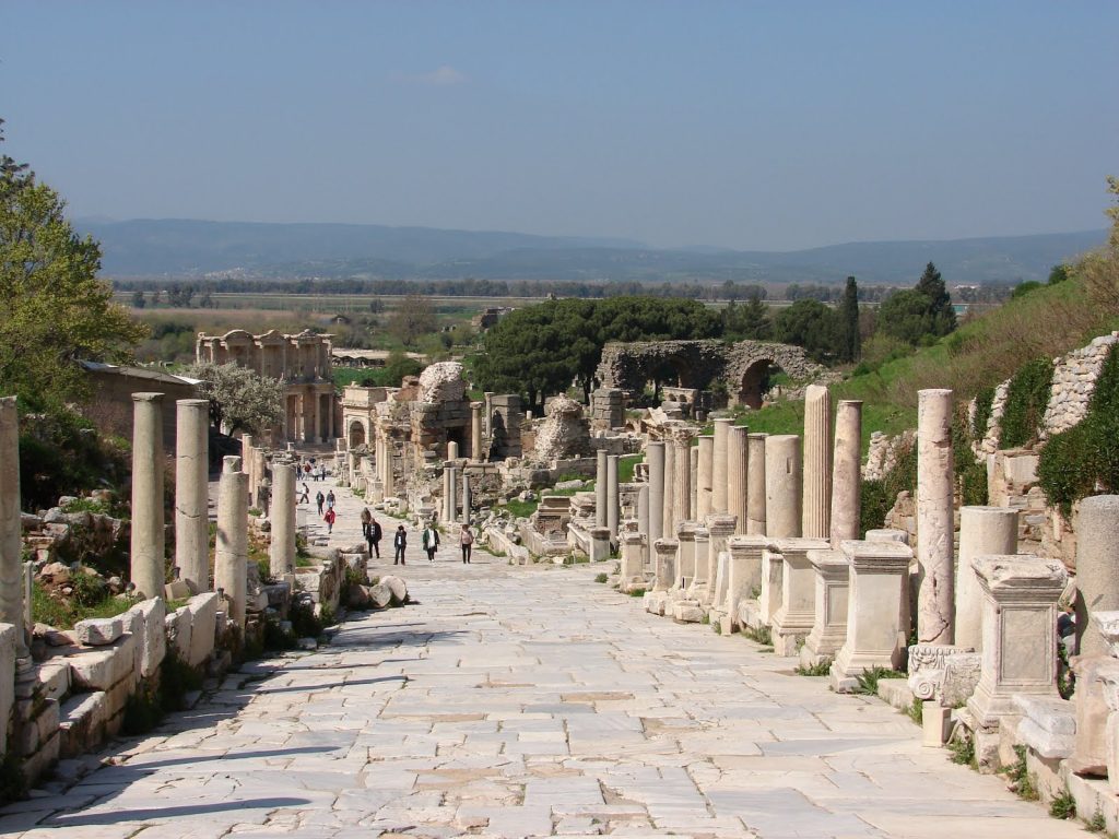
Another example is in Turkey in the Roman capital of Asia Minor, Ephesus where Queen Cleopatra sailed from Egypt to the Roman high command to meet Anthony, with a ceremony that is still enacted today for the tourists. Ephasis is a good 8km from the sea, so unless Queen Cleopatra was in need of a long walk, the shoreline has drastically changed since Roman times. The final and best example is Lewes in East Sussex, which is an incredible 15km from the coast. Moreover, this vast distance from the sea we see today is compounded by the fact that sea levels have risen by 2m over the last two thousand years, showing that the natural distance from these harbours to the coastline was even greater during the past.
The history books will tell you that this is down to either natural or manmade drainage, but why would you wish to allow a thriving harbour to silt up if it was commercially viable? In all three cases, this silting resulted in the houses or cities being completely abandoned or livelihoods lost, and the towns scaled down as a consequence. However, what is remarkable about all these locations is that they share in common factor and that the harbours were directly fed by rivers emptying into that area.These locations we built, at a time when the ground waters were high and the river flow was sufficient to flood the harbour allowing boats to sail in and out of the location.
This rise in groundwater was due to the ‘Post Glacial Flooding’ which occurred directly after the last Ice Age and had constantly been reducing in size affecting rivers all over Europe for the past 12,000 years. This is because the surplus water drains into the sea raising sea levels (that’s why sea levels over the past five years have risen although global warming has ‘plateaued’ and the Antarctic ice sheets increased in size) and cannot be replaced by the small amount of rainwater that tops up the groundwater in certain seasons.
The loss of this groundwater has been compounded over the last 1000 years as agriculture and the massive increase in populations have demanded we use more of this precious groundwater for drinking and manufacture processes and hence the loss of rivers and streams in hot summers. Moreover, this water will only be fully replenished when the next ice age covers Europe once again, so until then, this loss of groundwater we see affecting the shorelines of these ancient fortifications, and harbours will continue until the sea rise eventually floods the same area again, but not with fresh water this time, but with sea water.
4. Raised Beaches – that have never met the sea.

Science is a way of thinking much more than a body of knowledge. – Carl Sagan
A raised beach, marine terrace, or perched coastline is an emergent coastal land-form. Raised beaches and terraces are beaches or wave-cut platforms high above the current shoreline relative to a fall in the sea level. These are clearly seen in areas such as Norway or Scotland where the ice cap has compressed and sunk the ground surface layer (Isostatic Transformation) and has over thousands of years rebounded back to its original height.One of the classic cases of these ‘Raised Beaches’ is on the South Coast of Britain between Bournemouth and Brighton.
Unfortunately, an ice cap has never reached these areas during the last half a million years, although the raised beaches are sitting just 18” below the top soil.Theories of how this sandy layer that appears in the soil layers high in hill sediments are abundant, including British tsunamis (giant tidal waves that left sand deposits on hills).If you consult Wikipedia, it will tell you: “Tectonical and or eustatical use of marine terrace sequence”The total displacement of the shoreline relative to the age of the associated interglacial stage allows calculation of a mean uplift rate or the calculation of eustatical level at a particular time if the uplift is known.
To estimate vertical uplift, the eustatic position of the considered paleo sea levels relative to the present one must be known as precisely as possible. Our chronology relies principally on relative dating based on geomorphologic criteria but in all cases, we associated the shoreline angle of the marine terraces with numerical ages. The best-represented terrace worldwide is the one correlated to the last interglacial maximum (MISS 5e) (Hearty and Kindler, 1995; Johnson and Libbey, 1997, Pedoja et al., 2006 a, b, c). Age of MISS 5e is arbitrarily fixed to range from 130 to 116 ka (Kukla et al., 2002) but is demonstrated to range from 134 to 113 ka in Hawaii and Barbados (Muhs et al., 2002) with a peak from 128 to 116 ka on tectonically stable coastlines (Muhs, 2002). Older marine terraces well represented in worldwide sequences are those related to MIS 9 (~303-339 ka) and 11 (~362-423 ka) (Imbrie et al., 1984).
Compilations show that sea level was 3 ± 3 meters higher during MIS 5e, MIS 9 and 11 than during the present one and –1 ± 1 m to the present one during MIS 7 (Hearty and Kindler, 1995, Zazo, 1999). Consequently, MIS 7 (~180-240 ka; Imbrie et al., 1984) marine terraces are less pronounced and sometimes absent (Zazo, 1999). When the elevations of these terraces are higher than the uncertainties in paleo-eustatic sea level mentioned for the Holocene and Late Pleistocene, these uncertainties have no effect on overall interpretation.The sequence can also occur where the accumulation of ice sheets depressed the land so that when the ice sheets melt the land readjusts with time thus raising the height of the beaches (glacial- isostatic rebound)and in places where co-seismic uplift occurs. In the latter case, the terraces are not correlated with sea level high stand even if co-seismic terraces are known only for the Holocene.
What is more interesting is the note Wikipedia has placed with this explanation, which states: “This article may be too technical for most readers to understand. Please help improve this article to make it understandable to non-experts, without removing the technical details. The talk page may contain suggestions.” (September 2010)And here lies the problem with this theory – it’s far too complicated to be true!
This is a much simpler explanation geologist’s use:Raised beaches• When sea levels fall, more of the coastline is revealed. Beaches, no longer combed by wave are left, stranded and exposed above the new sea level.• These features are called raised beaches.• The lower part will often show signs of marine erosion, and a small cliff may be formed.• Any former cliff-line is also left stranded. No longer undercut by the sea that becomes a degraded cliff. Over time, it will often become clothed in shrubs and bushes – a sure sign of physical inactivity.Geologists have come up with this complex argument for a natural phenomenon because quite clearly we see sandy soil levels in hills and other places where we perceive that water has not been for some millions of years. In some countries, this geological problem can be easy dismissed as within the last 20,000 years (a relatively short and recent period in geological terms) these areas have had ice covering them from the previous ice age and the severe conditions that produce is always a good excuse for such events.
These events include the rising and falling of continents (isostatic transformations) although closer examination of these events that shows if they were causing these raised beaches the effect was limited.Geologists claim that raised beaches in Western Scotland have been recognised 8m, 15m and 30m above the present sea level and raised beaches can only technically exist and be seen in coastal areas as the surface area below the beach had to be cut away by the sea to reveal the raised beach. Now the first problem with this theory is that these beaches are at different levels. If you look at a map of the UK today, you will notice all the beaches are at one level – sea level. So this is where ‘localised’ factors are introduced to the geological equation.The sea in the past was lower than today and at the end of the last ice age it would have been some 60m lower – so these Scottish-raised beaches are not 8m, 15m and 30m higher than sea level but 68m, 75m and 90m.
5. Giant skeletons – found by French archaeologists now dismissed by today’s scientists.

Your theory is crazy, but it’s not crazy enough to be true. – Niels Bohr
Synopsis
In 1868, parts of five skeletons were discovered in the rock shelter, located in the famous Dordogne Valley of France – they called them Cro-Magnon. Recent research over the past 20 years or so, however, has led scholars to believe that the physical dimensions of so-called ‘Cro-Magnon’ are not sufficiently different enough from modern humans to warrant a separate designation.However, the Cro-Magnon’s found under the rock shelter were over a foot taller, twice as strong, lived longer and had a brain capacity 15% greater than the people who found them, and this is why the Victorians saw them as a sub-species of man and named them accordingly.
They were the first to paint and play musical instruments.Their size and statue allowed them to become the ‘megalithic stone builders’ of prehistory who used boats to travel throughout the known world and even the Greek philosopher Plato talked about them in his dialogues. So who were these ‘Cro-Magnons’ and for what political purpose have the anthropologists killed them off?
6. Quantum of Solstice – Pythagorean maths put to use four thousand years before he was born
If an elderly but distinguished scientist says that something is possible, he is almost certainly right, but if he says that it is impossible, he is very probably wrong. – Arthur C. Clarke
Synopsis
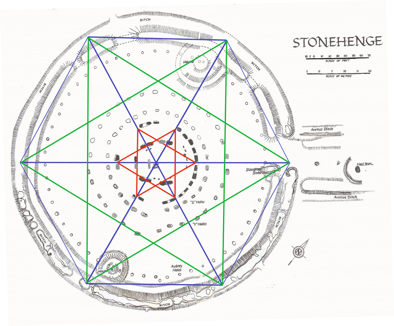
If we look at the skills of the what traditional archaeologists call the ‘Megalithic People’ – the civilisation that made the first stone monuments. We notice that to achieve such grand constructions, they would have required the advanced mathematics which to date have been credited to the ancient Greeks. By undertaking a closer detailed analysis of monuments such as Stonehenge and more importantly the mathematics used to design such monuments, we can see that these constructions that are ten thousand years old were in fact, based on sound and accurate trigonometrical theory.So how was Stonehenge planned and what can we see from the ‘blueprint’ what they knew about mathematics?
Firstly, Stonehenge was built in two very separate phases – current archaeologists are confused by the monument and dating of the structure, so if you read or browse the internet you will see the ‘traditionalist’ quote three to five phases. Moreover, these phases occurred AFTER the original monument was abandoned and thousands of years later, the ritualistic Celts occupied the monument and used it to worship the Sun and the Summer Solstice as we see reenacted today during the summer solstice.The First Phase took place at 8500 BCE when our ancestors built the original ditch made up of individual pits that were cut below the ancient groundwater table level to create a moat. This moat was used with the Bluestones to bathe away infections from cuts and bites which, if left untreated, would have turned into gangrene and lethal fevers.
For Bluestones (when wet) releases chemicals, including the most potential natural antiseptic – rock salt.The most amazing aspect is the accuracy of the diameter of this moat, which is exactly 360 ft (109.73m). This length is no accident or coincidence it is the reason that our angular and trigonometrical system revolves around 360!We have 12 months a year and each has a lunar cycle that lasts (from New Moon to New Moon ) 29.53 days. We have shown in my last book ‘The Stonehenge Enigma’ that there was 56 Bluestones (2 x 28), and we can show that this was used as a very accurate (99.8%) moon and eclipse calendar, which could compensate for the 0.47 day difference between the moon cycle and a 30 day standard cycle.It is, therefore, no surprise that the most ancient of calendars are 12 x 30 = 360 days in length.In history, we know that in the eighth century B.C.E., civilizations all over the world either discarded or modified their old 360-day calendars. The 360-day calendars had been in use for the greater part of the past millenniums. In many places, month lengths immediately after that change were not fixed but were based instead on observation of the sky.
Priest-astronomers were assigned the duty of declaring when a new month began – it was usually said to have started at the first sighting of a new moon. Month length at that time was simply the number of days that passed from one new lunar crescent to the next.During those years in Rome, for example, a Pontifex (priest) observed the sky and announced a new moon and therefore the new month to the king. For centuries afterward, Romans referred to the first day of each new month as Kalends or Kalends from their word calare (to announce solemnly, to call out). The word calendar derived from this custom.The ancient Babylonians in 4000 BCE used a calendar with alternating 29- and 30-day months. This system required the addition of an extra month three times every eight years, and as a further adjustment, the King would periodically order the insertion of an additional extra month into the calendar.
However, what is interesting is that monument becomes a ‘time capsule’ from our ancestors to show us that they understood the mysteries of mathematics. For when a circle that has a diameter of 360 ft has a moated circumference (the area around the edge of the circle) of 1130 ft in length. So if we divide the length around the edge 1130 by the diameter 360, we get a very interesting number 3.14 – why is this absorbing, because it’s what we know as PI or 3.14159!!So did the builders of Stonehenge leave us a message in stone?
7. Recent Landscape Flooding & Storms – the secret our ancestors knew about Britain’s weather

Synopsis
“Flooding is the major and most frequently recurring natural disaster in Britain. However, it is not a new phenomenon and geological information show where it has happened in the last 10,000 years” – British Geological Society.
BSG has published maps showing the remains of ancient waterways evidenced by the deposits of clay, sand and gravel; these are termed as “ alluvial deposits,” and they cover 10% of the mainland of Britain showing it was flooded directly after the last Ice Age – but there are further deposits of all a substances called ‘head’ made up also of Clay, sand and gravel, which show, in reality, that 40% of the land surface was flooded directly after the last ice age – the consequence is that the so-called ‘hunter/gathers’ could not have existed as portrayed in our history books, unless he had a boat.So why are these obvious geological features ignored by archaeologists and what could it mean to the history of Ancient Britain?
8. Mythological Dragons – a non-existent animal that is shared by the world.

Look deep into nature and then you will understand everything better. – Albert Einstein
Synopsis
A dragon is a legendary creature, typically with serpentine or reptilian traits, that features in the myths from many cultures. According to our popular history books, there are two distinct cultural traditions of dragons: the European dragon derived from folklore and ultimately related to Greek and Middle Eastern mythologies, and the Chinese dragon, with counterparts in Japan, Korea and other East Asian countries.
However, there are also Dragons in Central America and Africa, which are not as well known.But how can these groups of people separated by tens of thousands of miles dream up a ‘non-existent’ creature with the same look and features?Dragons appear in Wales, England, Greece, Slovakia, Indian, Persia, Asia Minor, Japan, China, Vietnam, and Australia and let us not forget (like the history books) Mexico, Central America, Ethiopia and Egypt.This actually places dragons on every continent in the World!The association of the serpent with a monstrous opponent overcame by a heroic deity has its roots in the mythology of the Ancient Near East, including Canaanite (Hebrew, Ugaritic), Hittite and Mesopotamian. Humbaba, the fire-breathing dragon-fanged beast first described in the Epic of Gilgamesh is sometimes described as a dragon with Gilgamesh playing the part of dragon-slayer.
The legless serpent (Chaoskampf) motif entered Greek mythology and ultimately Christian mythology, although the serpent motif may already be part of prehistoric Indo-European mythology as well, based on comparative evidence of Indic and Germanic material.Although dragons occur in many legends around the world, different cultures have varying stories about monsters that have been grouped together under the dragon label. Some dragons are said to breathe fire or to be poisonous, such as in the Old English poem Beowulf. They are commonly portrayed as serpentine or reptilian, hatching from eggs and possessing typically scaly or feathered bodies. They are sometimes portrayed as hoarding treasure.
Some myths portray them with a row of dorsal spines. European dragons are more often winged, while Chinese and African dragons resemble large snakes, while Central American Dragons have feathers. Dragons can have a variable number of legs: none, two, four, or more when it comes to early European and African literature.Dragons are often held to have major spiritual significance in various religions and cultures around the world. In many Asian cultures, dragons were, and in some cultures still are, revered as the representative of the primal forces of nature, religion and the universe. They are commonly said to possess some form of magic or other supernatural power and are often associated with wells, rain, and rivers.Narratives about dragons often involve them being killed by a hero, such as Chaoskampf in the mythology of the Ancient Near East, Archangel Michael and Saint George. The slaying of Vrtra by Indra in the Rigveda also belongs in this category.
This theme survives into medieval legend and folklore, with dragon slayers such as Beowulf, Sigurd, Tristan, Margaret the Virgin, Heinrich von Winkelried, Dobrynya Nikitich, Skuba Dratewka/Krakus. In Biblical myth, the archetype is alluded to in the descendants of Adam crushing the head of the Serpent, and in Christian mythology, this was interpreted as corresponding to Christ as the „New Adam” crushing the Devil.The blood of a slain dragon is depicted as either beneficent or as poisonous in medieval legend and literary fiction. In German legend, dragon blood has the power to render invincible skin or armor bathed in it, as is the case with Siegfried’s skin or Ortnit’s armor. In the Slavic myth, the Earth refuses it as it is so vile that Mother Earth wishes not to have it within her womb, and it remains above ground for all eternity.
The blood of the dragon in Beowulf has acidic qualities, allowing it to seep through iron. Heinrich von Winkelried dies after the blood of the dragon slain by him accidentally drips on him.So do Dragons exist?To find the answer to this question we need to ascertain what qualities or description constitutes a Dragon in each continent; this may give us an insight to whether these creatures are real or mythological, and if they are not real, what natural phenomena do they represent?
9. On Sunken land of the North Sea – was this the world’s oldest and greatest civilisation?

“The sea, once it casts its spell, holds one in its net of wonder forever”. – Jacques Yves Cousteau
Synopsis
After the last ice age, the ‘great melt’ flooded the landscape of Britain for over ten thousand years. This flooding started a chain reaction and as a consequence, the sea level slowly increased and vast areas of land were lost including a land mass known as ‘Doggerland.’Throughout the 19th century, oyster dredgers working the shallow waters off the north east coast of England recorded frequent finds of animal bones caught up in their nets.
These discover- is became a regular occurrence as the fishing technology increased and the trawlers at a later date and in deeper waters of the North Sea also found traces of civilisation and a lost continent. Sadly, the location and accuracy are rarely recorded with any degree of accuracy; this material appeared to come from some areas within the North Sea.One area where the greatest number of finds discovered is known as the ‘Dogger Bank’ which lies just 90km – 110km (60-70 miles) from the coast of the British Isles. This shoal (a shoal, sand- bar, sandbank or gravel bar is a somewhat linear landform within or extending into a body of water, typically composed of sand, silt or small pebbles.) rises about 45m (150 ft) above the North Sea bed, to the north it plunges into deeper water and forms a subterranean plateau covering 17,600 sq. km. (6,800 miles) With a maximum dimension being 260km (160 miles) from North to South and 95 km (60 miles) from East to West.
Over time, the number of finds reduced as the same area was dredged day after day and any artefacts sitting on the surface would have been scooped up and either returned as a curiosity or in a majority of the time just thrown back in a different location.Even so, items such as; bear, wolf, hyena, bison, woolly rhino, mammoth, beaver, walrus, elk, deer and most importantly horse has been collected. This precious collection of findings gives us a fantastic insight into what Doggerland looked like, the environment that supported these animals and the climate of this unique area of the world.It would be impossible to talk about Doggerland and its environment without understanding if there was a written history of a land that flooded thousands of years ago, and this comes in the works of the ancient Greek Philosopher Plato.
Over the years, Atlantis has grown to be both a legend and the source of many science fictions; this is neither correct nor helpful in tracing the history of humanity, as it moves the debate from scientific observation to fantasy and the degrading of the most important time in our history. Plato is a source of credible information as he is not a ‘story teller’ like some other historical writers. He is fundamentally a philosopher, whose writings are still studied even now, some 2,000 years after his death at the most famous and prestigious universities throughout the world. This man is not prone to fantasy or exaggeration, his writings, therefore, must be accepted as true evidence that once in the distant past a great ancient civilisation, did, in fact, exist, and that they changed the course of humanity in ways which I believe we do not fully understand to date.
10. Alexander the Great sailed into India – where no rivers now exist.

I came, I saw, I conquered – Julius Caesar
Synopsys
The Indian campaign of Alexander the Great began in 326 BC. Alexander was born July20, 356 B.C. in Pella, in the Kingdom of Macedonia. During his leadership, he united the Greek city-states and led the Corinthian League. He also became the king of Persia, Babylon and Asia, and created Macedonian colonies in Iran. After conquering the Achaemenid Empire of Persia, the Macedonian king (and now high king of the Persian Empire) Alexander launched a campaign in north west India (what is now Pakistan.) The Battle of the Hydaspes river against King Porus in Punjab is considered by many historians, as the most costly battle that the armies of Alexander fought.
The rationale for this campaign is usually said to be Alexander’s desire to conquer the entire known world, which the Greeks thought ended in north-western India. While considering the conquests of Carthage and Rome, Alexander died in Babylon on June 13, 323 BC. In 321 BC, two years after Alexander’s death, Chandragupta Maurya of Magadha, founded the Maurya Empire in India.The Battle of the Hydaspes River was fought by Alexander in July 326 BC against King Raja Purushottama (Poros) a Kshatriya on the Hydaspes River (Jhelum River) in the Punjab of Pakistan, near Bhera.
The Hydaspes was the last major battle fought by Alexander. The main train went into modern-day Pakistan through the Khyber Pass, but a smaller force under the personal command of Alexander went through the northern route, resulting in the Siege of Aornos along the way. In early spring of the next year, he combined his forces and allied with Taxiles (also Ambhi), the King of Taxila, against his neighbor, the King of Hydaspes.
Puru was a great King of Indus/ Asiatic continent. Arrian writes about Porus, in his own words “One of the Indian Kings called Porus a man remarkable alike for his strength and noble courage, on hearing the report about Alexander, began to prepare for the inevitable.Accordingly, when hostilities broke out, he ordered his army to attack Macedonians from whom he demanded their king, as if he was his private enemy. Alexander lost no time in joining battle, but his horse being wounded in the first charge; he fell headlong to the ground, and was saved by his attendants who hastened up to his assistance.” Porus drew up on the south bank of the Jhelum River, and was set to repel any crossings. The Jhelum River was deep and fast enough that any opposed crossing would probably doom the entire attacking force.
Alexander knew that a direct crossing would fail, so he found a suitable crossing, about 27 km (17 miles) upstream of his camp. The name of the place is ‘Kadee’. Alexander left his general Craterus behind with most of the army while he crossed the river upstream with a strong part of his army. Porus sent a small cavalry and chariot force under his son to the crossing.According to sources, Alexander first encountered Porus’s son in the past, so the two men were not strangers. Porus’s son killed Alexander’s horse with one blow, and Alexander fell to the ground. Arrian also writing about the same encounter adds that “Other writers state that there was a fight at the actual landing between Alexander’s cavalry and a force of Indians commanded by Porus’s son, who was there ready to oppose them with superior numbers, and that in the course of fighting he (Porus’s son) wounded Alexander with his own hand and struck the blow which killed his (Alexander’s) beloved horse Buccaphalus.”
The force was easily routed, and there isn’t any mention in any account that Porus’ son was killed. Porus now saw that the crossing force was larger, and decided to face it with the bulk of his army. Porus’s armies were poised with cavalry on both flanks, the war elephants in front, and infantry behind the elephants. These war elephants presented an especially difficult situation for Alexander, as they scared the Macedonian horses.Alexander did not continue, thus leaving all the headwaters of the Indus River unconquered. Afterwards, Alexander founded Alexandria Nikaia (Victory), located at the battle site, to commemorate his triumph. He also founded Alexandria Bucephalus on the opposite bank of the river in memory of his much cherished horse, Bucephalus, who carried Alexander through the Indian subcontinent, and died heroically during the Battle of Hydaspes.East of Porus’s kingdom, near the Ganges River (the Hellenic version of the Indian name Ganga), was the powerful Nanda Empire of Magadha and Gangaridai Empire of Bengal.
Fearing the prospects of facing other powerful Indian armies and exhausted by years of campaigning, his army mutinied at the Hyphasis River (the modern Beas River) refusing to march further east.As for the Macedonians, however, their struggle with Porus blunted their courage and stayed their further advance into India. For having had all they could do to repulse an enemy who mustered only twenty thousand infantry and two thousand horse; they violently opposed Alexander when he insisted on crossing the river Ganges also, the width of which, as they learned, was thirty- two furlongs, its depth a hundred fathoms, while its banks on the further side were covered with multitudes of men-at-arms and horsemen and elephants. For they were told that the kings of the Ganderites and Praesii were awaiting them with eighty thousand horsemen, two hundred thousand footmen, eight thousand chariots, and six thousand fighting elephants.
Gangaridai, a nation which possesses a vast force of the largest-sized elephants. Owing to this, their country has never been conquered by any foreign king: for all other nation’s dread, the overwhelming number and strength of these animals. Thus, Alexander the Macedonian, after conquering all Asia, did not make war upon the Gangaridai, as he did on all others; for when he had arrived with all his troops at the river Ganges, he abandoned as hopeless an invasion of the Gangaridai when he learned that they possessed four thousand elephants well-trained and equipped for war.This is a traditional account of how Alexander entered and fought in India. To access this land he had to travel thousands of miles east to a new land.
Traditionally, this campaign was seen as a route march over a barren desert land, which to be frank no-one in their right mind would attempt.However, recently a Photojournalist (not a historian) physically travelled the same path as Alexander the great and found that he used the waterways of the past which to date have been ignored as they are current too low to facilitate such a large army, but in the past, David suggests that the river was much larger than today.In search of the Alexander’s Lost World (TV Documentary), David Adams followed in the footsteps of the earliest Greek explorers, putting a new theory on Jason and the Argonauts to the test.
11. Antler Picks that built ancient monuments – although only one has been found at the largest stone circle in the world.

Science never solves problems without creating ten more – George Bernard Shaw
Synopsis
According to the history books, our ancestors built the great and numerous prehistoric sites using basic tools such as antler picks to cut the chalk bedrock and animal shoulder blades as a shovel.Some of these ancient constructions moved over half a million tonnes of chalk to create the likes of Silbury Hill – the largest prehistoric mound in Europe and Avebury with its massive 70 foot wide and 36 foot deep ditches that took eighteen million man-hours to build over very many years.Yet in Avebury only one buried antler has ever been found and less than a handful of tiny fragments found inside Silbury Hill.So how were these monuments really built and why has this false evidence made its way into our history books?
12. Columbus was the first Western Man to reach America – Yet bones and tools suggest that Europeans sail there ten thousand years earlier.
“We would like to live as we once lived, but history will not permit it” – John F. Kennedy
Synopsys
A blood type (also called a blood group) is a classification of blood-based on the presence or absence of inherited antigenic substances on the surface of red blood cells (RBCs). These antigens may be proteins, carbohydrates, glycoproteins, or glycolipids, depending on the blood group system. Some of these antigens are also present on the surface of other types of cells of various tissues. Several of these red blood cell surface antigens can stem from one allele (or very closely linked genes) and collectively form a blood group system. Blood types are inherited and represent contributions from both parents. A total of 32 human blood group systems is now recognized by the International Society of Blood Transfusion (ISBT).
The two most important ones are ABO and the RhD antigen; they determine someone’s blood type (A, B, AB and O, with + and – denoting RhD status).Many pregnant women carry a fetus with a blood type different from their own, and the mother can form antibodies against fetal RBCs. Sometimes these maternal antibodies are IgG, a small immunoglobulin, which can cross the placenta and cause hemolysis of fetal RBCs, which in turn can lead to hemolytic disease of the newborn called erythroblastosis fetalis; an illness of low fetal blood counts that ranges from mild to severe.
Sometimes this is lethal for the fetus; in these cases, it is called hydrops fetalis.One of the Greatest Mysteries in Anthropology is how the A Rh neg blood groups originated in North America.Blood groups are a good method to detect population migration in conjunction with modern DNA Haplogroups, as the former has been identified for over 100 years, unlike the modern method.An individual either has or does not have, the “Rhesus factor” on the surface of their red blood cells. This term refers only to the most immunogenic D antigen of the Rh blood group system, or the Rh- blood group system. The status is usually indicated by Rh positive (Rh+ does have the D antigen), or Rh negative (Rh- does not have the D antigen) suffix to the ABO blood type.
Our History books tell us… That according to the New World migration model, a migration of humans from Eurasia to the Americas took place via Beringia, a land bridge that connected the two continents across what is now the Bering Strait. The most recent point at which this migration could have taken place, where the first Americans set foot on Alaska, is 40,000 – 12,000 years ago; a hotly disputed topic.The early ‘stone age’ Paleo-Indians spread throughout the Americas, diversifying into many hundreds of culturally distinct nations and tribes. According to the oral histories of many of the indigenous peoples of the Americas, they have been living there since their genesis, described by a wide range of traditional creation accounts.While some indigenous peoples of the Americas were historically hunter-gatherers, many practiced aquaculture and agriculture.
The impact of their agricultural endowment to the world is a testament to their time and work in reshaping and cultivating the flora indigenous to the Americas. Some societies depended heavily on agriculture while others practiced a mix of farming, hunting and gathering. In some regions, the indigenous peoples created monumental architecture, large-scale organized cities, chiefdoms, states, and empires.Many parts of the Americas are still populated by indigenous Americans; some countries have sizable populations, especially Bolivia, Peru, Mexico, Guatemala, Colombia, and Ecuador. At least, a thousand different indigenous languages are spoken in the Americas. Some, such as Quechua languages, Aymara, Guaraní, Mayan languages, and Nahuatl, count their speakers in millions. Many also maintain aspects of indigenous cultural practices to varying degrees, including religion, social organization and subsistence practices.
Some indigenous peoples still lived in relative isolation from Western society, and a few are still uncontacted peoples.So, according to wiki:About 40,000 years ago Homo Sapiens walked across the land bridge of Alaska and entered America, finally going south to the reached South America all sharing the same blood type ‘O’, but then a second wave came across in 12,000 BP and brought the Blood type A, B and AB with them and settled only in North America.But there is a huge problem with this theory – apart from whom in their right mind would walk across a footbridge over a thousand years, to a cold and inhospitable place (Alaska)?
The Na-Dené, Inuit and Indigenous Alaskan populations exhibit haplogroup Q (Y-DNA); however, they are distinct from other indigenous Amerindians with various mtDNA and atDNA mutations. This suggests that the peoples who first settled the northern extremes of North America, and Greenland derived from later migrant populations than those who penetrated further South in the Americas. Linguists and biologists have reached a similar conclusion based on analysis of Amerindian language groups and ABO blood group system distributions.
On the East Coast of Asia (at the start of the footbridge) there is less than 4% Rh Neg blood, 90% of the Blood is ‘O’ type Rh-positive – 6% A,B or AB Rh-positive. So, if there were travellers that took the ‘land bridge across’ their descendants disappeared into extinction and never left a trace of interbreeding with the local peoples, even though they walked this pathway for thousands of years – not one stop to settle or cohabitate with a local resident.However, the Haplogroup Q (Y-DNA) shows clear migration from America to Asia and not vice-versa.
Moreover, the indigenous American Blackfoot Indians of North America are 82% A blood group RH Negative- the other 18% has probably a case of interbreeding since they were conquered by modern Europeans and their footprint stretches from the lakes of the east coast but falls short of the American West Coast or Alaska.So where did these people come from?
13. Was Troy really located in Turkey – if so why did it take Odysseus ten years to travel 200 miles get home to Greece.
The very ink with which history is written is merely fluid prejudice. – Mark Twain
Synopsys
Where Troy Once Stood is a book by Iman Wilkens, that argues that the city of Troy was located in England and the Trojan War was fought between groups of Celts.The standard view is that Troy is located near the Dardanelles in Turkey. Wilkens claims that Homer’s Iliad and Odyssey, though products of ancient Greek culture, is originally orally transmitted epic poems from Western Europe. Wilkens disagrees with conventional ideas about the historicity of the Iliad and the location and participants of the Trojan War.Copies of his book ranked high on Bookfinder’s list of most-wanted out of print books until 2005, when the latest revised edition was published. His work has had little impact on professional scholars.
Anthony Snodgrass, Emeritus Professor of Classical Archaeology at Cambridge University, has named Wilkens as an example of an “infinitely less-serious” writer.So what evidence does Wilkens use to prove that Troy was in Northern Europe?Wilkens argues that Troy was located in England on the Gog Magog Downs in Cambridgeshire. He believes that Celts living there were attacked around 1200 BC by fellow Celts from the continent to battle over access to the tin mines in Cornwall as tin was a very important component for the production of bronze.Wilkens writes that there are similarities between the river names in the Iliad and present-day England: “Homer names no less than fourteen rivers in the region of Troy.” The rivers Thames, Cam, Great Ouse and Little Ouse, to name a few, can respectively be identified as Temese, Scamander, Simois and Satniois, according to Wilkens.
The revised edition of 2005 contains a “reconstruction” of the Trojan battlefield in Cambridgeshire.13 ancient things that don’t make sense in History – TroyAccording to Wilkens, St Michael’s Mount is the site of Scylla and CharybdisWilkens further hypothesises that the Sea Peoples found in the Late Bronze Age Mediterranean were Celts, who settled in Greece and the Aegean Islands as the Achaeans and Pelasgians. They named new cities after the places they had come from, (similar to the migration of many place names to North America), and brought the oral poems that formed the basis of the Iliad and the Odyssey with them from Western Europe. Wilkens writes that, after being orally transmitted for about four centuries, the poems were translated and written down in Greek around 750 BC.
The Greeks, who had forgotten about the origins of the poems, located the stories in the Mediterranean, where many Homeric place names could be found, but the poems’ descriptions of towns, islands, sailing directions and distances were not altered to fit the reality of the Greek setting. He also writes that “It also appears that Homer’s Greek contains a large number of loan words from western European languages, more often from Dutch rather than English, French or German.” These languages are considered by linguists to have not existed until around 1000 years after Homer.Wilkens argues that the Atlantic Ocean was the theatre for the Odyssey instead of the Mediterranean.For example he locates Scylla and Charybdis at present day St Michael’s Mount.
To prove his theory Wilkens produces archaeological evidence, for instance, the Isleham Hoard in the battlefield, and etymological evidence, for instance, the location of Ismaros in Brittany at Ys or the location of Homer’s Sidon at Medina Sidonia in Spain. He also brings forth indications that Homer described locations around the Atlantic, with distinctive topographical features.Cádiz would match the description of Ithaca; “There is in the land of Ithaca a certain harbour of Phorcys, the old man of the sea, and at its mouth two projecting headlands sheer to seaward, but sloping down on the side toward the harbour… “Wilkens believes that Havana’s topography greatly resembles the description of Telepylos: The harbour, about which on both sides, a sheer cliff runs continuously, and projecting headlands opposite to one another stretch out at the mouth, and the entrance is narrow, “…, and the ships were moored within the hollow harbour, for therein no wave ever swelled, great or small, but all about was a bright calm…… “Wilkens mentions several sources for his ideas. Belgian lawyer Théophile Cailleux wrote that Odysseus sailed the Atlantic Ocean, starting from Troy, which was situated near the Wash in England (1879). Charles-Joseph de Grave thought that the historical and mythological background of Homer’s work should be sought in Western Europe (1806).
However, this is not the only source that shows the story could be of a different origin. The late Sir Moses Finley, Professor of Ancient History at University of Cambridge, concluded that ‘we are confronted with this paradox and that the more we know; the ‘worse off, we are’ and he, therefore, suggested that ‘Homer’s Trojan War must be evicted from the history of the Greek Bronze Age’. As it seems difficult to disagree with his conclusion, we are, in my view, left with only two options: the great Trojan War never took place in northwest Turkey and consequently; the Iliad is the fruit of pure imagination, or else; the war did take place, but in another country.
And Professor P H Damste (Universities of Utrecht and Leuven) “Valuable knowledge is to be discovered about the people of the Northwest European coast around 1200 BC, how they navigated the oceans and a great war between the Kings of continental Europe and the Trojan king in England, who held a monopoly of tin mining in Cornwall. Such information is encoded in the Iliad and Odyssey.”
And other facts show that the story may not be as straightforward as we once imagined for when we look at Northern Europe for signs of Troy, we get some interesting facts such as an old legend that Britain was founded by Brutus who led survivors from Troy here. Geoffrey of Monmouth wrote in his Historia Regum Britanniae an origin myth which traced the foundation of Britain back to the Trojans. This account described how Brutus, great-grandson of Aeneas of Troy, landed at Totnes, subdued the race of giants who lived there, and gave his name to the country he had pacified (Britain = Brutus).
These are the synopsys from the Book ’13 Ancient Things that don’t make sense in History’ for further extracts from the book go to our dedicated WEBSITE or if you wish to purchase the book either in softback FULL COLOUR or HARDBACK black and white from Amazon. For further information about our work on Prehistoric Britain visit our WEBSITE or VIDEO CHANNEL.